Map of Route
Height Profile

I
came across a couple of things last week that I thought were quite interesting,
the first is a Spanish word used to describe a hard challenging walk or track -
senderoextrem (sendero being a path or a track). The second was a local route
that I was not previously aware of - to the summit of the Divino mountain, but
starting in the Val d'Arc at the base of the mountain, as opposed to the top of
the Tagarina valley where we normally start from. So, I had a little chat with
my walking companion Eric, and after a bit of discussion we decided to try and
combine these two new learnings!
So,
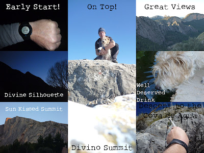
our day started at 07:00 before the sun had even got out of bed. We walked out
of Sella heading off down the Val d'Arc, past the climbers refuge and at 08:00
we arrived at the point where we turned left off the main track and onto
unfamiliar territory and a narrow path that, in theory, would lead us up the
mountain to its summit which stood some 570m (1870 ft) above us. As we started
our ascent I was pleasantly surprised by how reasonably defined the path
actually was (I had expected nothing). On a few occasions it did seem to
disappear, but we may have actually wandered off it, before finding it again a
bit higher up. I'm not sure if it is a man path or a pig path, probably a
combination of the two. It was not long before we came across a short run of
scree that we had to ascend, but not too long or too difficult. Once we were
approximately three quarters of the way up the mountain, the vegetation gave
way to rock slabs that anyone who has walked on the Peña de Sella will be
familiar with, and this meant the going got slightly easier. It was now just a
question of enjoying the views, keep moving up and eventually and quite suddenly
both the summit and familiar territory came into view - 10 minutes later we
were on the top. As I sat looking at the view, Eric in meantime was looking at
a herd of deer that were traversing the mountain below us, fortunately he did
not give chase! Our ascent from the bottom of the valley to the top of the
mountain had taken just under one and a half hours.
We
now descended via the normal route to the Font de Alemany where we took on more
water before heading up onto the Peña de Sella. Once on the Peña, as we were
heading up to the first of the three ascents, Eric decided to take a slightly
different route, not unusual behaviour on his part, and I continued, expecting
to meet him at the top. Once on this first summit I waited, and called out to
Eric, and waited, and whistled and waited. I then started to retrace my steps,
calling and whistling but still no sign. I did a full circle, descending and
re-ascending, but alas nothing. I then repeated this circuit again continually
calling out to my companion (the gauge on my concernometer gradually getting
higher and higher). On my third sweep I finally spotted some movement below,
not however my companion, but at least a possible explanation - more deer
traversing the mountain. My suspicions were that he had either seen them or
picked up on their scent and gone off in pursuit, which meant that he could now
be absolutely anywhere, but hopefully not down a ravine. I continued my circuit
ending up back at my high point which gave me good views far into the distance,
but still no sign of my little white companion. So, my plan now was to return
to the font, thinking that after a 'chase' he may of returned there in search
of water. I was hoping the Spanish farmer who I had bid good morning to as he
tended his land just above the font on our way up was still there. As I
approached, I saw him talking with two other locals (both of whom I knew) so I
went over and made enquiries as to whether they had seen my dog? One of them
immediately asked if it was a small white one - 'yes, yes, white and brown' my
excited response, relief swept through me as he told me that he had seen Eric
down at the font. I thanked them and quickly continued on my way. As I went
round the next bend, who should be coming up in the opposite direction, my not
so faithful little friend! He was looking slightly sheepish, but apart from
that quite pleased with himself - I gave him a bit of a talking to, explaining
the risks of splitting up with no defined plan in place when high in the
mountains, my words were hard, but my tone was soft, I was so relieved to have
found him and that he was alright. So, bearing in mind that this unexpected
extension to the days walk had added nearly 2 hours we now had a choice,
abandon it and phone for a lift, or to continue? I knew that I had to walk back
up onto the Peña to get a signal on my phone so that gave me a few minutes to
make my decision. It was a perfect day, clear blue sky, the temperature was
around 20 degrees C. and in spite of the 2 hour 'dog hunt' the time was still
only 12:30 so, taking all that into account plus the fact that I don't like to
give up on an idea the decision was to continue.
We
made good time traversing the Peña and the only decision left to make was
whether to make our decent via a route we know well directly behind Sella, or
to continue with our original plan and descend via The Water Cave (Cova de
Agua), where the path has almost no definition, its a route that I don't know
well and one I knew would fall into the senderoextrem category!
The
descent to the cave went well, aided by red paint marks which lead the way and
fixed ropes in a few places, we arrived much quicker than expected. From the
cave there are no red paint marks to assist and it's not so much a question of
finding the safest route down, but more a question of finding the least
dangerous route down! However, we took our time and although on occasions I had
to assist Eric down some of the steeper sections, we eventually reached the
landmark that we had been aiming for, a lonely pine tree from where a path
leads you through the forrest to the road and back to Sella.
We
both slept very well that night!
Conclusions
- there are various routes from Sella up onto the Peña de Sella/Divino (5 that
I know of) all of them are challenging (some more than others) but reward you
with incredible views and a great sense of achievement. As far as routes back
down again, while it it possible to descend all of them, there are only 2 that
I would recommend. The first is get someone to meet you in the Tagarina valley
and come back down in a car! or if that's not possible or like me you would
consider that to be 'cheating' then the PRV 198 & 199 route directly behind
Sella that goes past the phone mast, is in my opinion the most defined, and
easiest route (that does NOT mean easy!)
MHS Feb 2012


 Met up with a couple of chums this morning while out walking the Colera/Ruta de Agua Route.


 The why not try using it as your walking guide? The local Sella walk 'The Ruta de Agua - SL CV 112' is now available at EveryTrail.com complete with map, route, photos, video and POI - with lots of info.